|
Many remote-sensing missions of the earth, i.e. by ENVISAT, Landsat,
Ikonos, Quickbird, ERS, RapidEye, TerraSAR-X and airborne supported ERS, rise multimodal geo-data
in form of multispectral optical images as well as radar data in different polarity
and resolution. These can be introduced to solve several manifoldly tasks.
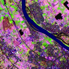
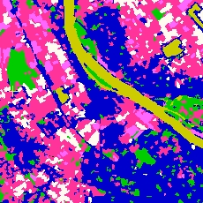
The main-topic of the joint projects ENVILAND / ENVILAND 2 is the creation of land-cover mapping as a
result of an automatic image processing task.
Tasks, like automatic mapping of cereal crop, estimation of biophysical parameters
and coverage of change dynamics, have to be solved by this way. Subject of this
work is the development of a processing pipeline as software prototype.
Each processing step takes on specific task (geocoding, edge extraction,
registration, segmentation, classification). At this huge amount of data has to be handled (standard-size: 12000x12000 pixels).
The thematic main focus of the Zentrum für Bild- und Signalverarbeitung (ZBS)
is the development of registration- and segmentation-algorithms and their efficient
integration. In addition to this, several classification- (i.e. SVM & Ensemble-Systems ) and
threshold-extraction-algorithms and concepts were made available and tested (see processing chain below, results of our work can be found in the red-tagged parts).
|